Dodgedrone: Obstacle Avoidance for UAVs

Description
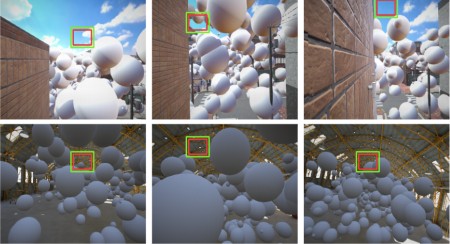
We train ResNet with single instances of RGB images to predict traversable paths for a UAV. The images, obtained from the DodgeDrone Simulation environment, were labelled in self-supervised way by taking the maximum average depth of the patch as a criterion. The model was fed with positive examples of obstacle-free patches (in green), and the idea here is to avoid obstacles during navigation by moving the UAV towards the center of the predicted patch (in red).
The motivation here is to utilize these self-supervised labels and learn a good initial estimate for optimal policies, avoiding resouce-intensive trials.
Ongoing and future works include the following:
- Using the center of the patch to obtain linear velocity commands through Radial Flow.
- Integrating the network with Habitat Simulation for end-to-end high-level control.